A Leading Weather
Software Solution Provider
Software Solution Provider
In today's interconnected world, meteorology is not an isolated field but rather increasingly integrated with various other systems, often outside the realm of traditional meteorology.

Visual Weather and Open Weather enable users to share a broad range of weather data and visualisations through OGC (Open Geospatial Consortium) compliant web services. Meteorological maps created in Visual Weather with their full customisability can be published via the OGC Web Map Service (WMS) protocol. Visual Weather also supports the publication of data through the OGC Environmental Data Retrieval (EDR) protocol, as well as the older WCS and WFS standards.
These web services are the key component to various national and international Open Data initiatives such has The EU Directive 2019/1024 (or former INSPIRE - INfrastructure for SPatial InfoRmation in Europe).


Visual Weather and Open Weather support the following standard outputs and protocols:
OGC Web Map Service (WMS) 1.1.0, 1.1.1, 1.3.0 with OGC Best Practice for using Web Map Services (WMS) with Time-Dependent or Elevation-Dependent Data (1.0);
OGC Web Coverage Service (WCS) 1.0, 2.0.1
OGC Web Feature Service (WFS) 1.0, 1.1
Our focus is also on providing efficient data retrieval through the OGC Environmental Data Retrieval (EDR) API, which is an OpenAPI based RESTful API 1.0.1, 1.1, 1.2.
Serving the diverse needs of its users, Visual Weather and Open Weather support a variety of output formats. This means you can receive weather data in the format that suits your requirements best, enhancing interoperability and ease of use:

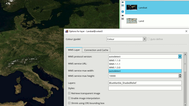
The WMS (Web Map Service) client data layer in Visual Weather can integrate external OGC Web Map Server services as data providers, allowing users to incorporate outputs from other GIS (Geographic Information Systems), such as ArcGIS, GeoServer, MapServer or many others. WMS is the most widely used geospatial integration protocol, with many institutions worldwide publishing their data through this standard. In the meteorological domain, organisations such as ECMWF, NOAA, EUMETSAT, the UK Met Office, and KNMI are prominent examples.
Beyond meteorology, WMS is also utilised by various other leading institutions and datasets across different fields. For instance, environmental agencies, geological surveys, and urban planning departments often employ WMS to disseminate spatial data. Organisations like the United States Geological Survey (USGS), the European Environment Agency (EEA), and UNESCO provide access to vital datasets through WMS, covering topics such as land use, biodiversity, and water resources. These applications demonstrate the versatility and widespread adoption of WMS as a key tool for geospatial data sharing across diverse disciplines.