Visual Weather

Visual Weather

Visual Weather is a world-leading meteorological software for data reception, processing and representation of meteorological data, monitoring of incoming messages and values, automated and user-driven production and many other functionalities for fulfilling the tasks of a meteorological service. Its architecture supports multiple data formats, ensuring seamless integration with diverse tools and environments. Its unique flexibility and scalability makes it deployable at various types of meteorological institutions.
Visual Weather

Why choose Visual Weather 

Visual Weather is designed to supply meteorological institutions with software that will cover the majority of their operational requirements. Primary clients of Visual Weather are national meteorological services, private weather services, aviation and military authorities that benefit from its key functionalities for data integration, visualisation, interactive display and automated output generation and from myriad other functionalities for task management, user-driven production of textual and graphical outputs, monitoring, alerting and more.

Visualisation without limits

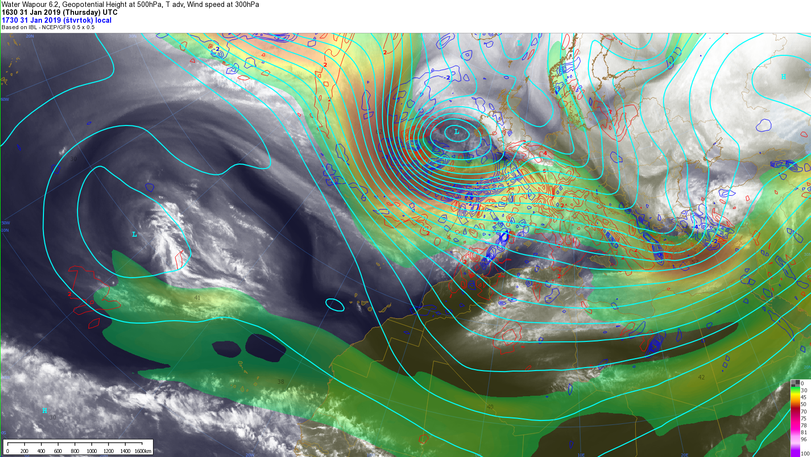
Visual Weather provides unparalleled visualisation options that allow to display any data in your preferred way, overlay it with other data and zoom into any part of the world.

  • All data can be joined in a single display
  • Comfy interface for customising the visualisation with immediate effect
  • Visualisations can be adapted according to available data and the needs of each customer
  • Specified data and visualisation combo can be saved as a preset for fast and easy access

Analyse to get the weather story right

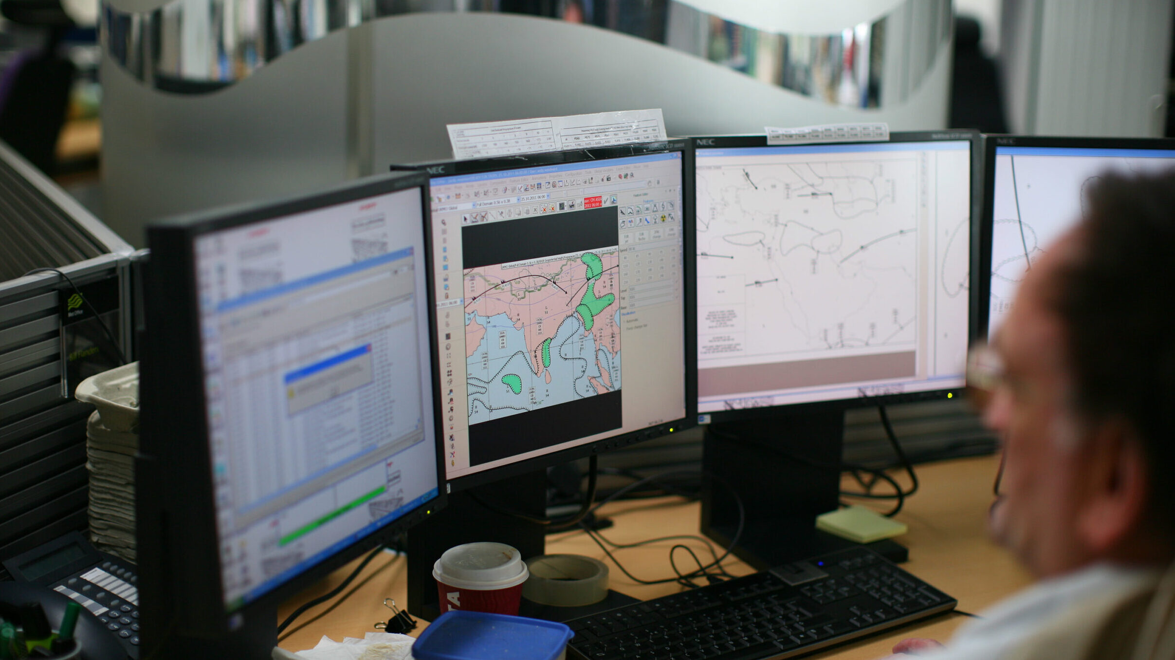
Interactive tools to interrogate the data that help forecasters to build a detailed understanding of the weather story. 

  • Analyze the observations and verify the model data
  • Utilize thermodiagrams to examine the vertical structure of the atmosphere
  • Track and predict the movement of weather phenomena
  • Use meteograms to evaluate weather trends for any selected location
  • Modify the points of a cross-section to track weather along flight routes

Meet the needs of the public 

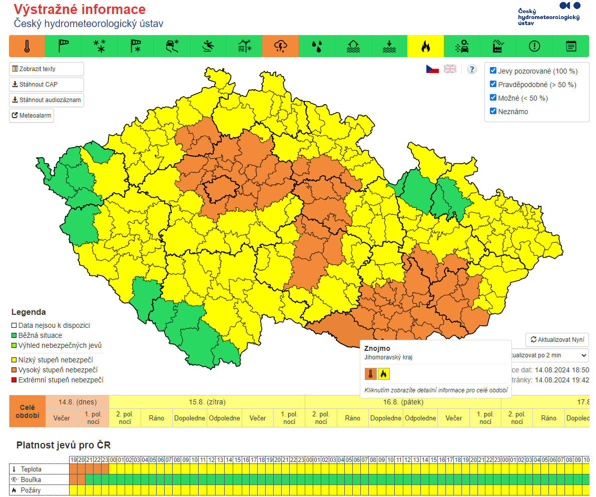
The primary mission of meteorological services is to keep citizens and industries informed about the current or upcoming weather and possible dangerous threats. Visual Weather will help you in providing quality weather forecasts and timely alerts for the public and for sectors that rely on accurate weather information, supplying the following:

  • Role-based task management
  • Text and graphical production using automatic data input and forecasters’ contributions based on their expertise
  • Full automation of tasks that do not require human intervention
  • Extensive delivery mechanisms (e-mail, web upload, etc.)

Aviation forecasting made easy

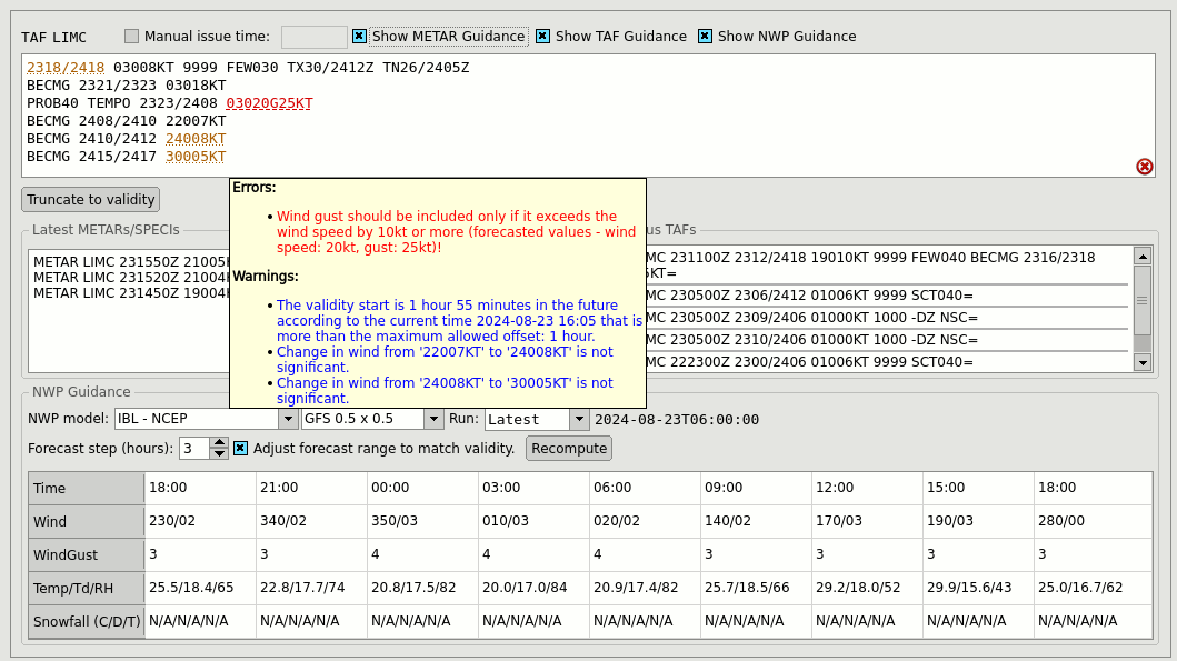
Reliability, ease of use, speed and efficiency – Visual Weather has all the essentials that aviation meteorology requires. The tools remove all the difficulties that you may encounter in issuing aviation products:

  • Convenient drawing of significant weather charts
  • Easy graphical creation of SIGMETs
  • Syntax checking TAFs and other standard messages
  • TAF, SIGMET and AIRMET output in IWXXM
  • Monitoring TAFs against observations
  • Keeping track of amendments and issued warnings

New horizons with Web Services

In today's interconnected world, meteorology is not an isolated field but integrated with other systems, often outside the realm of traditional meteorology. Visual Weather enables users to share a broad range of weather data and visualisations through OGC (Open Geospatial Consortium) compliant web services. Customised meteorological maps created in Visual Weather can be published via the OGC Web Map Service (WMS) protocol. Visual Weather also supports the publication of data through the OGC Environmental Data Retrieval (EDR) protocol, as well as the older WCS and WFS standards.

Furthermore, Visual Weather can utilise OGC services as data providers, enhancing your own data. It includes a WMS client data layer, and EDR or WCS services can be seamlessly integrated into Visual Weather’s grid processing engine, functioning just like traditional NWP, satellite, or radar data.

Powerful tools for experts

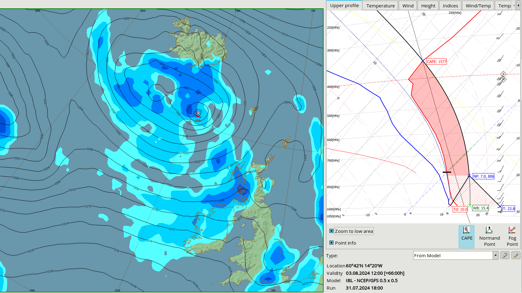
Visual Weather has a number of advanced features that will take the forecasting capabilities to the next level.

  • Computation tool and over a thousand of ready-to-use functions let you create scientific calculations over the received data to visualise model differences, thermodynamic indices, vorticity etc. 

  • The system can be extended by creating your custom plugins and using Visual Weather as a development platform for building your own additional weather forecasting applications and functionalities

Extensible and flexible to fit your needs

Visual Weather has a portfolio of features and functionalities as it was developed to fulfil the different needs of forecasters, scientists, data managers and it can be used by meteorological offices, aviation authorities or private companies or educational institutions. 

  • Module-based approach to tailor the software to your specific needs and provide the most cost-effective solution for your institution 
  • A system that can grow together with your needs
  • Extensible by integrating your custom plugins

Handling large volumes of diverse data

Visual Weather supports most of meteorological standard formats off the shelf, and its extensibility allows to integrate all your weather data. State-of-the-art technologies ensure that the meteorological services are able to cope with the expanding volume of meteorological data. 

  • Receive, store and process data from a wide range of data sources 
  • Produce output in multiple formats and deliver it in multiple ways
  • Support for custom formats through  integration interface
  • Handling large data volumes, such as high-resolution models, multiple ensemble datasets, next-generation satellites

Scalable and compatible

Deploy Visual Weather according to the needs of your service.  

  • Perfectly scalable architecture allows you to deploy the system in a way that matches your structure  
  • Support for thin-client solutions (Citrix, ThinLinc, MobaXterm) to permit working from home or remote offices
  • The system runs on a variety of platforms (Linux, Windows)
  • We can assist you with setting up the operational environment, or Visual Weather can adapt to your existing structure seamlessly

Expertise from Customer Base

Visual Weather is used by 70+ organisations worldwide. Its development is based on long-term cooperation and the expertise of this wide customer base. We even meet up annually at our User Group Meeting.
Join UGM

Legendary Support

Our support is the most valued service, and our team of experts is available 24/7 to fix critical issues, upgrade your systems and provide advice. Prompt and useful support is an essential part of our products.
Contact support

Compliant with Standards

Visual Weather fully complies with the applicable requirements of WMO, ICAO and OGC standards and recommendations. We take special care in integrating all the new standards and formats.
Compliance details
© 2005 – 2024 IBL Software Engineering. All Rights Reserved.
Webdesign by Art4web. Development by YNK media.