Online Weather

Online Weather

Online Weather, web-based forecasting software, is designed to empower informed decision-making and streamline planning. With a user-centred interface built using modern technologies, like HTML5, JavaScript and WebGL, it offers a smooth and intuitive experience across all devices, ensuring seamless operation. Whether you're in the field at a customer site, monitoring conditions at sports events, or managing weather-related emergencies, our software provides the flexibility and reliability to make critical decisions on the go.

Interactive weather charts

Online Weather can visualise meteorological observations, numerical models (NWP), satellites, radar layers, lightning, and geospatial backgrounds (such as Google Maps). It supports zooming and panning for detailed views with real-time updates.

  • Easily add, remove, hide or reorder map layers from any WMS server, including Visual Weather
  • Get detailed information for each data layer for a specific location
  • Timeline control for selecting validity times
  • Engage with animated visuals to enhance data exploration
  • Save and instantly access favourite layers
  • View Meteograms based on NWP model data or observations

Graphical production

Online Weather provides an interface for users to collaboratively create, customise, and annotate visual representations of weather phenomena, such as weather zones, fronts, and other features. The products can be published on websites, and social media, integrated into mobile & web applications or sent to customers.

  • WYSIWYG editing for seamless updates
  • Draw different weather features directly on the map
  • Annotate drawn features with descriptive labels
  • Collaborate with multiple users, seeing all changes in real-time
  • Integrate additional tools (such as data layers, profiles, timeseries)
  • Highly extensible to accommodate new products and feature types

Impact on route-based operations

Online Weather allows the display of interactive cross-sections for flights or marine routes, providing insights into how meteorological conditions affect them and enabling enhanced planning and decision-making.

  • Display route cross-sections for selected routes on the map
  • Select and adjust validity and route points
  • Monitor thresholds for aviation and marine routes
  • Color-coding of route segments based on thresholds
  • Automatically include relevant parameters for selected route types
  • Easily show/hide relevant parameters in cross-sections

Weather impact matrix

Online Weather allows the assessment of weather impacts on different assets and allows the monitoring of real-time impacts, ensuring task safety and efficient planning.

  • Evaluate weather impact on military, aviation, marine equipment
  • Define assets, tasks, and weather thresholds for monitoring
  • Instant impact forecasts for safe task execution
  • View activities on a map with Red-Amber-Green (RAG) colour highlight

Atmospheric profile analysis

Online Weather enables users to display profiles, view hodographs, access tabulated upper air data, adjust profile displays, and compare profiles from different locations and times.

  • Display and compare upper air profiles
  • View atmospheric diagnostic tables
  • Display hodographs of upper air data
  • Interactive convection analysis (such as Normand's point)
  • See detailed tooltips with point information from all profiles

Text-based production

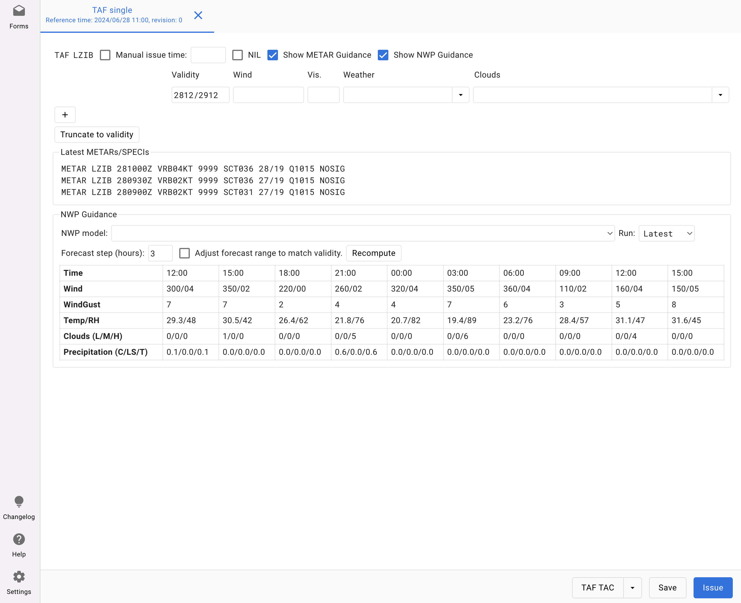
Online Weather enables the creation and issuing of text-based forecasts and alerts through customisable entry forms. The forms can be designed by the users or by IBL. For aviation users, a standard suite of forms is available to cover the production of TAF, METAR, Aerodrome & Windshear warnings, or Special AIREP. A single entry form can result in multiple outputs (text, HTML, PDF, LibreOffice, JSON, XML), with the graphical quality limited only by the design effort invested. Results can be published on websites, social media, sent to newspapers, customers, or integrated into mobile & web applications.

  • Web-based front-end for Visual Weather's Message Editor
  • Output to TAC & IWXXM for aviation reports.
  • First-guess values (NWP model data, calculations)
  • Embedded guidance (model data, images, external sources)
  • Validation to reduce format & logical consistency errors
  • Reuse values between forms
  • Customise output with templates
  • Output as text, HTML, PDF, LibreOffice, JSON, XML
  • Revision tracking for corrections, amendments, and cancellations
  • Insert logos and any additional graphics

Messages

Online Weather allows the display of bulletins based on headings and sorting or filtering them for easy access.

  • Display any bulletin from the database based on heading or filters
  • Filter bulletins by heading or preconfigured filters
  • View detailed content of selected bulletins
  • Print selected bulletins with customisable printing options

Weather reports

Online Weather enables direct access to METARs, TAFs, and other reports, supporting flight planning with current conditions and forecasts and ensuring safe and informed decision-making.

  • Display METARs and/or TAFs from specified stations and/or areas
  • Translate from IWXXM format for seamless integration
  • Select stations from the map interface for streamlined access
  • Customise grouping by report type or station
  • Highlight report details with customisable colours

Notifications

Online Weather lets users view bulletins with automatic notifications, ensuring timely updates on critical weather alerts, operational changes, or important announcements.

  • Display bulletins with automatic user notifications
  • Filter, sort, and discard notifications for easy management
  • View detailed content and images within notifications
  • Set and mute sound alerts for new notifications
  • Print notifications with customisable print settings

Web Services under the hood

Online Weather leverages web services like Web Map Service (WMS) and OGC Environmental Data Retrieval (EDR) to efficiently process vast amounts of environmental data close to its source on the server side. By utilizing these services, complex calculations and data processing are performed directly on the server, significantly reducing the amount of data that needs to be transmitted over the network. This approach ensures that the client application receives only the small, final results of these calculations, such as a specific weather map or precise environmental data for a chosen location. As a result, users benefit from fast, responsive access to detailed weather information without the need to handle or download large datasets, making the platform both efficient and scalable.

Expertise from Customer Base

Online Weather is used by organisations worldwide. Its development is based on long-term cooperation and the expertise of this customer base. We even meet up annually at our User Group Meeting.
Join UGM

Legendary Support

Our support is the most valued service, and our team of experts is available 24/7 to fix critical issues, upgrade your systems and provide advice. Prompt and useful support is an essential part of our products.
Contact support

Do You Want to Know More?

Send an mail to sales@iblsoft.com to get more information about Online Weather. We will prepare a proposal for installing or upgrading Online Weather based on your needs.
Contact sales
© 2005 – 2024 IBL Software Engineering. All Rights Reserved.
Webdesign by Art4web. Development by YNK media.
cross